News
Stay tuned for the latest news of events, product release, features, updates, tips and more.


Date: 2020-11-13 1714
Good new for “Spatial Manager for GstarCAD” users, the Spatial Manager 6.3 version has been released with some new features and improvements, as well as full compatibility with GstarCAD 2021 !
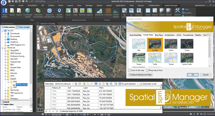
Some of the new options of Spatial Manager 6.3 shown in the picture
Transform the drawing Coordinate Reference System (CRS)
The SPMTRANSFORMCRS function has been completely redesigned in order to improve its effectiveness. In addition, the process no longer starts from an empty template but the transformed drawing is an exact copy of the original but recalculating all the objects geometry. Now when transforming a DXF the resulting drawing is saved as DXF, not as DWG. Read more about it

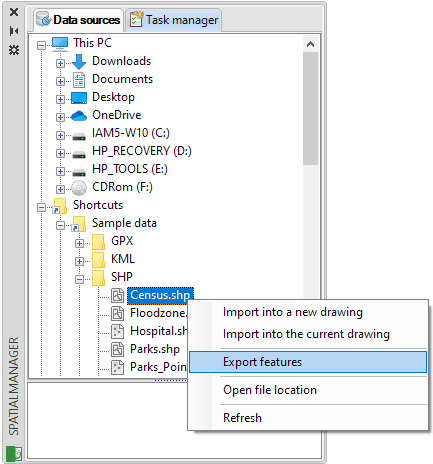
Import / Export
A new tool has been added allowing to Export directly from one data source to another, without the need to import previously in your drawing to Export it later
This tool can be found in the data sources and tables contextual menus in the application main palette. Read more about it

File selection on Import/Export processes has been improved and new preset locations, new icons, etc. have been added. Read more about it
Now it is possible to manage resources and accesses, create Shortcuts and User Data Sources (UDS), etc. from the direct Import and Export windows. No need to return to the main application palette to do that. Read more about it
Now, if the option "Import only Features in the current view" is activated when Importing a table or Importing-all tables from any WFS server, the reading of elements from the server will be filtered and only those that fit that spatial filter will be downloaded (A great time and performance advantage)
The ASCII data provider default parameters have been modified so that now the separator is the comma and the decimal delimiter is the period (More standard in most industries)
The KML/KMZ data provider is updated in order to allow reading of elements belonging to custom schemes.
Automation of creating a non-existent folder when executing a defined Export task to that folder has been included.
Dynamic Background Maps
You can find a new option to Ignore or Invert the coordinate axes orientation for WMS and WMTS user Background Maps. This adds more compatibility with some servers. Read more about it
The image download method when capturing any Background Map has been improved.
Coordinate systems
The EPSG tables (CRSs and other objects) have been updated to version 10.003
Please note: Some functions are only available in the Standard or Professional editions
Please feel free to download the new version and try it now !

2020-12-25
2020-11-13
2020-11-13

2020-09-03
2020-09-02
2020-07-30

2020-07-20

2020-04-20
